

VANCOUVER, British Columbia, November 5, 2025 (GLOBE NEWSWIRE) — Mustang Energy Corp. (CSE: MEC, OTC:MECPF, FRA:92T) (»Company” or “Mustang“), in connection with Skyharbour Resources Ltd. (TSX-V: SIH), is pleased to announce the results of a high-resolution HTDEM study on the 914W uranium project (“Project“), totaling 136 linear kilometers. The project has access roads and is located in a promising region known for its mineral potential south of the Athabasca Basin. The 914W TDEM study successfully identified well developed conductive zone within the framework of the Project. The geometry and strength of the anomaly correspond to graphitic basement rocks or alteration zones associated with faultsboth are favorable for unconformable uranium mineralization.
A time domain electromagnetic (TDEM) survey using the Xcite™ helicopter was conducted Axioma Exploration Group LLC according to the project, covering about 136 linear kilometers. The study simultaneously collected electromagnetic, magnetic and radiometric data to map conductive, magnetic and radiometric variations associated with prospective uranium-bearing structures. The study was conducted in addition to TDEM research being conducted by Mustang as part of the nearby Spur project.
The early time channels (0.014–0.045 ms) (Fig. 1) show strong high amplitude electromagnetic responses along the east-central portion of block 914W, indicating shallow conductive zones near the surface. This conductor persists in mid to late time channels (0.12–0.56 ms) and may represent graphite horizons or fault-controlled alteration zones, a key feature of uranium prospecting in the Athabasca Basin margin environment. The intensity and continuity of the anomaly decreases slightly with later decay times, consistent with a discrete subsurface conductor rather than surface noise.
Figure 1: Aerial HTDEM survey of Project 914W showing 0.045 ms time channels with strong high amplitude electromagnetic responses along the east-central portion of Block 914W.
Inversion modeling at depths from 50 to 350 m shows consistent conductivity characteristics. At depths ranging from 50 to 150 m (Fig. 2), a strong, continuous conductive zone is visible extending east to northeast across the east-central portion of the feature. Sections at depths from 250 to 350 m show that the conductivity anomaly persists at depth.
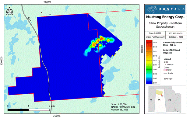
Figure 2: Aerial HTDEM survey of Project 914W showing electromagnetic responses along a conductivity depth slice at 150 m depth showing high response along the east-central portion of Block 914W.
Soil sampling results 914W 2025
In May 2025, a week-long program of prospecting and soil sampling was conducted at the Project site. A total of 25 rock samples and 142 soil samples were collected. Soil sampling was concentrated in the northwest corner of the Project, immediately south of the Scurry Rainbow E area. 1 and troughs of Lake Don 2 where there is no exit to the surface. Rock sampling was limited due to the paucity of outcrops in the area.
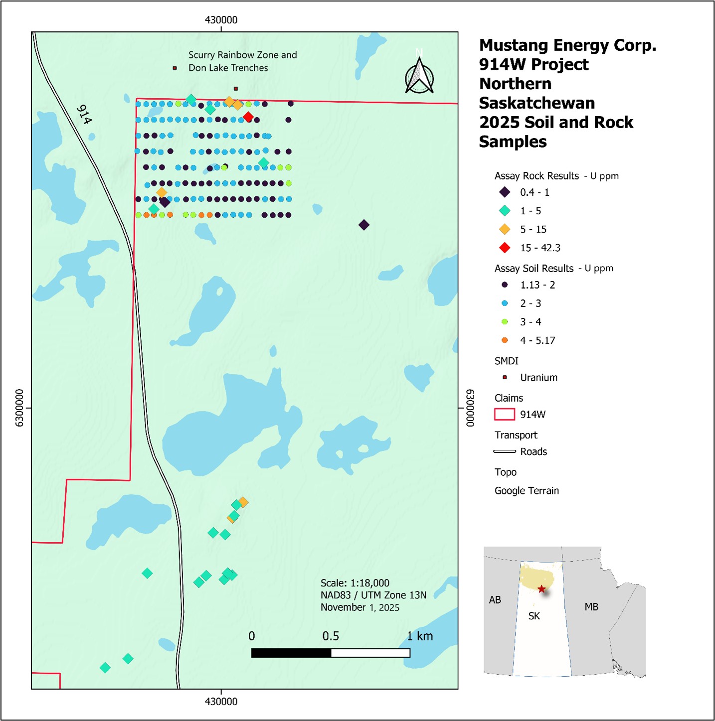
Figure 3. 2025 Project 914W soil and rock sample analysis results – U ppm
Although the program did not identify any new significant discoveries, particularly in the southern part of the Project, the northern soil grid showed anomalous uranium values. In this program, five soil samples from the southern part of the grid had uranium levels exceeding 4 ppm, which could be considered slightly elevated.
Prospecting has not confirmed elevated uranium values in the southwestern part of the grid, likely due to limited outcrop exposure. However, anomalous uranium values were identified in the northeastern part of the soil grid, including a granite gneiss sample that showed a uranium content of 42.3 ppm.
Sampling methods
Samples were sent for analysis to the SRC laboratory in Saskatoon, SK. Both rock and soil samples were tested using tetra-acid digestion ICP-MS, total tetra-acid digestion ICP, and ICP U₃O₈ analysis reported as mass percent.
The A horizon soil samples were collected by removing surface vegetation with a trowel and sampling the topmost soil layer. Rock samples were taken from exposed basement boulders or granite outcrops that gave elevated meter per second (cps) readings.
About the 914W uranium project:
The project consists of two claims covering 2,440 hectares. It is located approximately 48 km southwest of Cameco's Key Lake deposit, providing convenient logistics and access via Highway 914. The project is located within the West Wollaston area, known for unconformity and basement uranium mineralization. The project is located in an area with favorable geological conditions, with local graphite-bearing formations. Directly north of the project is the Scurry Rainbow E area. 1where 1288 ppm U was found in well ML-1, and in the gutters of Lake Don 2where surface exploration revealed up to 0.64% U3ABOUT8 in a trench in zone E of Lake Don 2. Although several geophysical and geological studies have been conducted in some areas of the property as part of historical exploration, much of the Project remains underexplored.
Mustang Company acquired an interest in the Project in accordance with an option agreement (“Option agreement“) with Skyharbour Resources Ltd. pursuant to which Mustang may acquire a 75% interest in the Project subject to the satisfaction of certain conditions. Additional information regarding the Option Agreement can be found in the Company's press release dated November 13, 2024 posted on the Company's profile on SEDAR+.
The Company advises that, despite the proximity of the location, mineral discoveries in or near the Scurry Rainbow E Zone, the Lake Don Basin and Cameco's Key Lake Deposit, and any promising results thereof, are not necessarily indicative of mineralization or occurrence within the Project area, or the Company's ability to commercially exploit the Project or discover any commercially exploitable deposits therein. The Company cautions investors not to rely upon this information as the Company has not verified the accuracy or reliability of the information.
Links:
- SMDI# 1961, ML-1 Borehole or Scurry Rainbow E Zone, derived from: https://mineraldeposits.saskatchewan.ca/Home/Viewdetails/1961
- SMDI #1983, Radioactive Zones C, D and E of Lake Don, retrieved from: https://mineraldeposits.saskatchewan.ca/Home/Viewdetails/1983
Qualification Statement
The scientific and technical information in this press release has been reviewed and approved by Troy Marfleet, Professor of Geophysics, Technical Consultant, Mustang Energy, Registered Member of the Association of Professional Engineers and Geologists of Saskatchewan. Mr. Marfleet is a qualified person as defined in National Instrument 43-101.
About Mustang Energy Corp.:
Mustang Energy is a Canadian mineral exploration company focused on the discovery and development of high-potential uranium and critical mineral deposits. The company owns a 147,153-hectare portfolio of strategically located properties in the Athabasca Basin in Saskatchewan, one of the world's largest uranium districts. Mustang advances early stage exploration through modern techniques and a disciplined, data-driven approach. The company strives to create long-term value through responsible exploration and a focus on high-impact targets in underexplored areas. For more information contact:
Mustang Energy Corp.
Attention: Nikolay Luksha, General Director and Director
Phone: (604) 838-0184
Neither the CSE nor the Market Regulator (as that term is defined in the policies of the CSE) accepts responsibility for the adequacy or accuracy of this release.
This press release contains certain statements and information that may constitute forward-looking information within the meaning of applicable Canadian securities laws. Forward-looking statements relate to future events or future results and reflect the Company's management's expectations or beliefs regarding future events. Generally, forward-looking statements and information can be identified by the use of forward-looking terminology such as “intends,” “believes,” or “expects,” or variations of such words, phrases or statements that certain actions, events or results “may,” “could,” “should,” “occur,” or “occur.” This information and these statements, referred to herein as “forward-looking statements”, are not historical facts, are made as of the date of this press release and include, but are not limited to, statements regarding discussions of future plans, estimates and forecasts, and statements regarding management's expectations and intentions with respect to, among other things, the future potential of the mineral resources owned by the Company, the results of the current exploration phase of the Project and the completion of future work on Project. In making forward-looking statements in this press release, the Company has made several significant assumptions, including, but not limited to, the assumption that the Company will be able to continue exploration of its properties, taking into account various environmental and economic factors beyond its control, and that the Company will be able to achieve the expected results from exploration of the Project. Although the Company's management has attempted to identify important factors that could cause actual results to differ materially from those contained in forward-looking statements or forward-looking information, there may be other factors that cause results not to be as expected, estimated or intended. There can be no assurance that such statements will prove to be accurate, as actual results and future events could differ materially from those anticipated in such statements. Accordingly, readers should not place undue reliance on forward-looking statements and forward-looking information. Readers are cautioned that use of such information may not be appropriate for other purposes. The Company does not undertake to update any forward-looking statements, forward-looking information or financial projections incorporated herein by reference except as required by applicable securities laws.
The infographic accompanying this announcement is available at:
https://www.globenewswire.com/NewsRoom/AttachmentNg/3df62d83-173d-45cc-b0e0-9effb4e68bc9
https://www.globenewswire.com/NewsRoom/AttachmentNg/8ed7e200-7676-47e8-b556-cf45f25b265a
https://www.globenewswire.com/NewsRoom/AttachmentNg/1d51bf92-08b7-49d1-8345-3e1647dcdc09


